Filipino hard-core mountaineers are understandably infatuated with Mount Guiting-Guiting, the imposing jagged-peaked mountain in the island of Sibuyan in Central Philippines. Albeit shorter than Mount Apo by 900 meters, “G2” is the more physically demanding mountain to climb, putting to test a mountaineer’s mettle and resolve when (s)he is confronted by fears (of height) and doubts (of making it to the summit).
From the intimidating views of its saw-toothed peaks and steep rock faces, it is clear that advanced mountaineering skills, physical stamina and endurance – and plenty of water – are required to make it to the summit. Because of the challenges it demands, G2 has earned the moniker of being the “K2 of the Philippines.” K2 is a “Savage Summit” that is more exacting to climb than Mount Everest.
In recorded history, G2’s summit has only been reached in 1982 by members of the Philippine Mountaineering Society based in Bacolod City, Negros Occidental, and members of the University of the Philippines Mountaineers. From a compilation of the photos below, it is clear that G2 requires more effort than usual to reach its peak.
Magdiwang is one of the towns from which mountaineers can jump off to G2. The other jump-off point is from the town of San Fernando. The traverse route starts from San Fernando to Magdiwang; the reverse-traverse route is from Magdiwang to San Fernando.
Camp 1 is two hours away from the jump off point in Magdiwang. A water source can be found one hour before reaching Camp 1.
Mountaineers can set up camp at Camp 2 as night falls. Further up is Camp 3, two hours away from the previous camp and about 20 minutes away from the last water source on the way up. (Mabel Spring can be found before the 90-degree rock face on the way to the summit, but the presence of water is highly unpredictable.)
Bulod Spring, named after a local guide, is one of the few springs where mountaineers can stock up on water which will prove to be scarce on the way up. Many mountaineers have decided not to pursue the summit because of lack of water from here on until the peak.
Mayo’s Peak was named after a pioneer mountaineer in G2 and a member of the Philippine Mountaineering Society. The team reached this peak on the occasion of Mayo Monteza’s birthday.
The Knife Edge Trail is so named because on both sides of the trail are steep ravines.
There is a pass in G2 known as “Kiss the Wall.” It was so named because a mountaineer has to “kiss the wall” as s(he) ascends the steep slope.
The Peak of Deception was so named because mountaineers often mistake this peak as the summit of G2. It is also otherwise known as the “Peak of Decision” because one has to decide whether to pursue the climb or not, particularly if faced with exhaustion and dehydration. From here, it would only take about 45 minutes to an hour to reach the summit.
The 90-degree wall is the last steep climb to the summit of G2. Some mountaineers have called this rock face as the “Hillary Pass” in reference to that famed mountaineer who first summited Mount Everest.
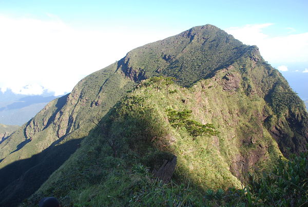
From afar, the summit of G2 is actually obscured by the Peak of Deception. But topographical surveys have shown that this unassuming peak is the highest point in the island of Sibuyan.
“Guiting-guiting” in the local dialect means “jagged.” This ridge best describes why the locals decided to name it like they did.
Photos by Lester Lope and Maevin Poncejan-Recto